
In-town homes
Older housing stock can bring established streets and convenient access, along with renovation history that deserves a careful inspection.
Communities, access, homes, acreage, local services, and the property details that change from one address to the next.

Jefferson County is not one uniform market. Access, lot size, utilities, road responsibility, and property condition can change quickly, so compare the actual address—not only the city name on the listing.
Jefferson County begins at the southern edge of St. Louis County and stretches through suburban corridors, established small cities, unincorporated communities, wooded terrain, river valleys, farms, and acreage.
Guide reviewed August 2026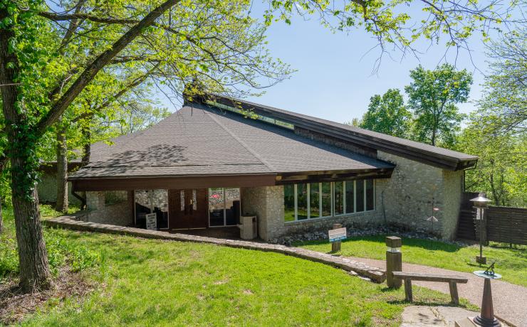
Mastodon State Historic Site connects Jefferson County’s landscape with the nationally significant Kimmswick Bone Bed.
Jefferson County is part of the Greater St. Louis region, directly south of St. Louis County. Its communities range from denser suburban areas near the northern edge to smaller cities, unincorporated areas, and rural properties farther south and west.
See where Jefferson County sits within Missouri.

The I-55 side connects communities along the eastern portion of the county with St. Louis County and the city. Route 21 serves the western side and connects a different set of communities and rural areas. Drive time can vary materially by exact location, time of day, road work, and the route required to reach an interstate or major highway.
For a move, test the actual trip at the times you expect to travel. A short distance on a map can feel different when the first part of the drive uses two-lane roads.
Properties may be inside a municipality or in an unincorporated part of the county. That can affect permitting, road responsibility, utilities, trash service, code enforcement, and which office handles a question.
Before buying, confirm jurisdiction, utility providers, sewer or septic status, water source, road maintenance, and any recorded restrictions for the specific parcel.
These are orientation zones, not rigid market boundaries. Conditions still need to be verified at the parcel.
| Area | Examples | Typical access pattern | Property questions to prioritize |
|---|---|---|---|
| Northern county | Arnold · Imperial · High Ridge | Shorter connection to St. Louis County through I-55, Route 21, Route 30, and Route 141 depending on the address. | Municipal boundary, traffic route, sewer district, subdivision restrictions, and drainage. |
| Eastern I-55 corridor | Barnhart · Pevely · Herculaneum | I-55 and US 61/67 provide the main north–south spine with local connections between river-oriented communities. | Interchange access, road projects, flood review, industrial adjacency, utilities, and city limits. |
| Festus–Crystal City | Festus · Crystal City | A paired local-service center along US 61/67 and I-55 with retail, medical, and civic destinations. | Exact municipality, housing age, lot drainage, renovation history, and daily route. |
| Central and western county | Hillsboro · Cedar Hill · House Springs | Route 21, Route 30, and two-lane county roads shape trips through wooded and rolling terrain. | Slope, driveway, culverts, road maintenance, septic or well systems, and internet availability. |
| Southern county | De Soto · rural southern Jefferson County | Longer regional trips with access depending heavily on the exact road used to reach Route 21, Route 110, or US 67. | Acreage usability, private systems, outbuildings, easements, emergency access, and travel time. |
Jefferson County includes traditional neighborhoods, older in-town homes, subdivisions, larger lots, acreage, and properties with outbuildings or private systems.
Older housing stock can bring established streets and convenient access, along with renovation history that deserves a careful inspection.
Review association documents, recorded restrictions, municipal services, drainage patterns, and how the surrounding road network handles daily traffic.
Evaluate usable land, slope, access, fencing, drainage, maintenance demands, and whether outbuildings are permitted and functional.
Confirm the actual system type, location, records, condition, capacity, and maintenance history instead of relying on a listing summary.
Determine whether the road is state, county, municipal, private, or maintained through a separate agreement.
Look for permits where applicable and verify that additions, decks, finished basements, and utility work were completed appropriately.
Each community has its own housing patterns, access, services, and practical tradeoffs.
Jefferson County provides property mapping, permitting, inspections, road information, tax services, courts, public safety resources, and other countywide functions.
Individual cities may operate their own parks, streets, utilities, police, planning, and community programs. Availability varies by location.
Parks, rivers, trails, sports facilities, conservation areas, and private outdoor space all contribute to local recreation, but the closest options depend on the community.
I-55, Route 21, US 61/67, and the local road network create different access patterns. Compare the actual route to the destinations you use.
A municipality can change permits, utilities, police, streets, code administration, parks, and trash service. Verify jurisdiction by parcel.
Public water and sewer are common in some areas; wells, septic, community systems, and other arrangements appear elsewhere.
Acreage totals do not explain slope, woods, drainage, access, fencing, easements, or the maintenance required to use the land.
State, county, municipal, subdivision, and private roads carry different maintenance responsibilities and practical conditions.
Age, renovation history, foundation type, drainage, roof, utilities, additions, outbuildings, and deferred maintenance shape ownership cost.
Jefferson County reports 12 park areas open to the public totaling about 283 acres. The broader area also includes municipal parks, Missouri state sites, conservation land, rivers, trails, sports facilities, and privately operated recreation.
Mastodon State Historic Site in Imperial connects outdoor trails with the nationally significant Kimmswick Bone Bed archaeological site. Other destinations vary from river access and picnic space to athletic facilities and community parks.
River bottoms, creek valleys, wooded hills, subdivisions, cleared pasture, and denser in-town parcels all appear within the county. That variety is a strength, but it also changes drainage, driveway design, mowing, erosion, tree maintenance, flood review, and usable acreage.
Property evaluation should connect the building to the land around it. Water movement, slope, culverts, retaining structures, and neighboring drainage are part of the home.
The site preserves the Kimmswick Bone Bed, where evidence tied humans to mastodons in eastern North America, along with a museum and trails through the surrounding landscape.
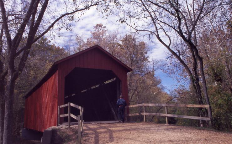
The 1872 bridge is one of Missouri’s remaining covered bridges and a compact stop that makes the county’s rural-road history tangible.
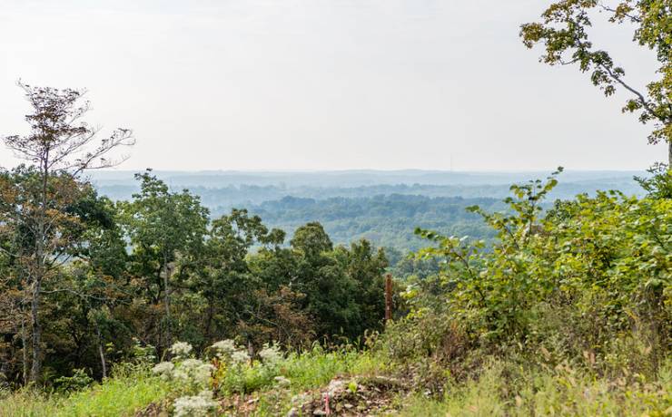
Sandstone box canyons, shelter caves, cliffs, glades, and wooded hills in the LaBarque Creek watershed explain why western Jefferson County feels so different from the I-55 corridor.
Jefferson County is spread across multiple municipalities and service districts, so the nearest destination depends on where the property sits.
Mercy identifies its Festus campus as a 251-bed acute-care hospital with a 24-hour emergency department and diagnostic, preventive, and restorative services.
The public community college’s main campus is in Hillsboro, with another instructional location in Arnold. The Hillsboro campus spans more than 400 acres.
The county seat concentrates the assessor, recorder, planning and zoning, public works, courts, permits, and other county functions. Many services also have online entry points.
Roads provide the primary transportation network. OATS serves Jefferson County, but availability, schedules, eligibility, and trip requirements should be checked directly.
Municipalities, sewer districts, water providers, electric utilities, trash companies, fire districts, and road agencies do not all share the same borders. Two nearby homes can have different providers and different billing or maintenance responsibilities.
Use the exact parcel and service address when checking providers. A seller disclosure or listing field is a starting point, not the final record.
Jefferson County’s County Services and Code Enforcement department includes planning, code enforcement, solid waste, and animal control. Public Works handles county roads and bridges, engineering, and stormwater responsibilities.
On rural and acreage property, also confirm well records, septic type, propane ownership, private-road agreements, internet at the address, and who maintains culverts or shared access.
Census figures describe the county as a whole; individual communities and neighborhoods can look materially different.
Jefferson County contains multiple commute corridors, school districts, municipalities, unincorporated areas, and property types. One countywide median cannot price an individual home.
Median sale price, price per square foot, days on market, concessions, and appreciation should be calculated from the same current MARIS dataset and refreshed on a dated schedule. Until that feed is authorized, the guide uses Census housing benchmarks and property-specific comparable analysis instead of mixing portal numbers.
Arnold and Imperial, the Festus–Crystal City area, the Route 21 corridor, De Soto, northern subdivisions, lake developments, and rural acreage do not behave as one market. Compare like location, construction, lot, services, condition, and sale terms.
Outbuilding size, setbacks, livestock, home occupations, short-term rental use, and permit requirements depend on city or county zoning, recorded restrictions, lot size, and existing approvals. County planning and the applicable municipality must review the exact parcel.
Missouri assesses residential real estate at 19% of market value. The final bill applies the combined levies serving the parcel—such as school, fire, ambulance, library, road, city, and other districts—so two similarly priced homes can have different bills.
Jefferson County contains numerous public districts, private and parochial options, early-childhood programs, career education, and Jefferson College. Attendance boundaries do not follow postal city names.
| Resource | What it provides | How to use it |
|---|---|---|
| Missouri DESE directory and report cards | Official district and building directories, enrollment, staffing, programs, and state accountability data. | Compare factual program information; avoid treating one score as a complete description. |
| Jefferson County district locator | A geographic starting point for district boundaries. | Confirm enrollment directly with the district using the property address before making a decision. |
| Jefferson College | Community-college programs from the Hillsboro campus and Arnold location. | Review current certificates, degrees, workforce programs, admissions, and course delivery directly. |
| Licensed childcare search | Missouri’s current provider and licensing records. | Ask each provider about openings, age groups, hours, transportation, fees, and wait-list timing. |
County government, municipalities, special districts, cooperatives, utilities, and private providers can all serve one address.
The county administration center connects residents to the assessor, collector, recorder, planning and zoning, code enforcement, roads, GIS, permits, courts, public notices, and council records. The Assessor’s office is open Monday–Friday, 8 a.m.–5 p.m., at 636-797-5466.
Water may be municipal, district, community, or private well. Wastewater may be sewer or on-site. Electric, gas or propane, trash, and internet territories also vary. Confirm providers before closing and ask about deposits, transfer timing, equipment ownership, and final meter readings.
Use the FCC National Broadband Map for reported fiber, cable, fixed-wireless, DSL, and satellite availability, then confirm the serviceable address and installation timeline with the provider. A neighbor’s connection does not guarantee the same service.
Call 911 for emergencies. Jefferson County 911 Dispatch lists 636-797-9797; the Sheriff’s Office lists 636-797-5538; county Emergency Management lists 636-797-5381. City police, fire-protection districts, and ambulance districts vary by address.
Regional sources identify Fox C-6, Mercy’s Jefferson County hospital and clinics, Jefferson College, the National Geospatial-Intelligence Agency’s Arnold campus, and manufacturing employers including Dow, Doe Run, Metal Container, Sinclair & Rush, Unico, LMC Industries, and Superior Solvents among major employment anchors.
The Jefferson County Economic Development Corporation and local chambers maintain changing directories for contractors, professional services, independent retail, restaurants, and community organizations. Listings on this site should identify the source and never imply Kyle’s endorsement without his express review.
Mastodon State Historic Site, Don Robinson State Park, Sandy Creek Covered Bridge State Historic Site, and Washington State Park each offer a different look at archaeology, geology, architecture, rivers, trails, and regional history.
Use Missouri Department of Conservation’s place finder for current hunting, fishing, boating, hiking, camping, and wildlife-area amenities. Confirm seasons, permits, ramp status, and site rules before a trip.
Arnold, Festus, Crystal City, De Soto, Hillsboro, Pevely, Herculaneum, and other communities operate parks, pools, libraries, athletic fields, trails, or community programs. Amenities and residency rules vary.
County council, planning, zoning, parks, public-safety, municipal, chamber, school, fair, market, and festival calendars change throughout the year. The guide’s calendar links should pull from official feeds as those integrations are approved.
Enter quotes or tax figures for the addresses you are comparing. This keeps insurance, utility, and tax differences visible without relying on a generic cost-of-living score.
Annual total$0
Annual total$0
Request the current utility, emergency-contact, government, school-calendar, and move-in checklist in one printable packet.
Request the packetKyle can help identify the jurisdiction, utility setup, access, private systems, zoning questions, and due-diligence items tied to a property you are considering.
Ask Kyle about an addressBoth. The northern and I-55 corridors include denser suburban and small-city development, while central, western, and southern areas include unincorporated property, wooded lots, farms, and acreage. The actual parcel is more useful than the county label.
There is no honest countywide number. Arnold and Imperial are materially closer than De Soto or western rural addresses. Test the exact route during the times you expect to travel and include the local-road portion before the highway.
Possibly, but not universally. Public systems, private wells, septic systems, community systems, and different provider boundaries all appear in the county. Verify each address.
Not always. A postal city can extend beyond incorporated limits. Check the parcel map, tax record, and municipality or county directly before assuming which rules and services apply.
Usable land, drainage, slope, driveway and road access, fencing, easements, well and septic systems, outbuildings, utilities, internet availability, and the ongoing labor and cost of maintaining the property.
Verify district and attendance boundaries directly by the specific property address. Boundaries and assignments should not be inferred from a postal city, subdivision name, or third-party listing page.
Start with the question you have today. No pressure and no generic sales pitch.